
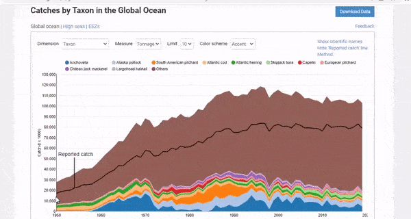
The Sea Around Us is pleased to announce that the marine fisheries catch data and derived indicators on its database have been updated to the year 2019.
After months of intensive work, we can now proudly say that time series with 70 years’ worth of data (1950-2019) are available for free viewing or downloading on www.seaaroundus.org.
This update required our teams to manage over 10 billion rows of data, the largest compilation of information we have processed in the past 23 years.
Our regular catch data update includes information by Exclusive Economic Zone (EEZ), Large Marine Ecosystems (LME), Marine Ecoregions (ME), Regional Fisheries Management Organizations (RFMO), High Seas, Global and FAO Area, and Marine Ecosystems, that is, estuaries, coral reefs, remaining inshore area, fronts in EEZ, seamounts in EEZ and remaining EEZ area.
The documentation of data, methods, and assumptions used for this update are presented for each country and territory in the “reconstruction references” section.
Another recent feature added to the website is a database on Marine Protected Areas (MPAs), presented as country-level MPA pages. For most countries, one major MPA is presented in terms of its area, official designation, and level of protection, as assessed in the published literature and via a questionnaire sent to local stakeholders.
We welcome feedback from users of our data, particularly in terms of elements that can be improved.
To provide feedback and/or request large datasets, please follow the instructions on this page. Users must be aware that large requests may involve a collaboration with the Sea Around Us team.