

The Marion Dufresne off the “port” of Crozet. East Island in the background. Photo by Dimitri Damasceno, Wikimedia Commons.
World Oceans Day (WOD), the initiative proposed in 1992 by Canada at the Earth Summit in Rio de Janeiro and officially recognized by the UN in 2008, aims to catalyze collective action for a healthy ocean and a stable climate.
Some of the yearly campaigns thousands of organizations run, inspired by this goal, are guided by the annual action theme that NGO The Ocean Project proposes for WOD. The Ocean Project, together with the World Ocean Network, led efforts to get the UN to recognize June 8th as World Oceans Day.
For 2026, the action theme is “Strong Marine Protected Areas for our blue planet,” which is meant to build on the momentum of recent agreements, such as the 2022 Kunming-Montreal Global Biodiversity Framework and the High Seas Treaty ratified in 2025, and push for stronger ocean conservation actions.
To support this endeavour, every month from January to June 2026, the Sea Around Us will take a deep dive into one MPA in its database and use this blogging space to share, in lay language, what factors make it a successful or unsuccessful MPA.
French Southern and Antarctic Lands
In January, we are taking a look at the French Southern and Antarctic Lands (Terres Australes et Antarctiques Françaises – TAAF), as it was among the worst-performing MPAs in the Sea Around Us’ Paper Park Index.
The area, comprised of the Crozet Archipelago, the Kerguelen Islands, the Saint-Paul and Amsterdam Islands in the southern Indian Ocean, as well as 60 small sub-Antarctic islands, was designated as a national nature reserve in 2006 and enlarged in 2016 to cover more than 672,000 km². Since March 2017, the regulatory framework also applies to the entire EEZ, covering 1.66 million km².
Three-quarters of the marine protected area allow for human activities, which are regulated but not entirely banned.
The TAAF Authority manages the reserve and requires impact assessments and manager approval for all activities in the regulated zones, including measures to mitigate bycatch and interactions with marine mammals and birds, such as “move on” rules if marine mammals are present and specific gear requirements.
The location of these islands, where the cold Antarctic waters are mixed with the warmer waters of the Indian Ocean, makes it a place where large breeding colonies of pinnipeds and king penguins, gentoo penguins, eastern rockhopper penguins, and macaroni penguins can be found, while the waters are home to populations of toothfish and forests of macrocystis and New Zealand bull kelp.
Within the Terres Australes et Antarctiques Françaises reserve, there is a 120,167-km2 Strict Marine Protection Zone where no extractive activity is allowed. However, according to a study by BLOOM Association, a French NGO, the place where protection is supposed to be more stringent is located in an area that has never been the subject of industrial fishing.
To get to this conclusion, BLOOM assessed all fishing activities in the French Southern Territories from 2015 to 2022. After analyzing over 46,000 lines of satellite data corresponding to 159,000 hours of fishing, the NGO demonstrated that the strictly protected zone precisely avoids the areas that are exploited by eight French fishing vessels of 55 to 76 meters in length, mainly targeting Patagonian toothfish and lobster.
In fact, from 2015 to 2019, almost 29,000 tonnes of Patagonian toothfish were caught in the Kerguelen and Crozet Islands, valued at $188 million, data from the Sea Around Us show. This is enough fish to fill out 11.5 Olympic-sized swimming pools. In addition to this, 3,800 tonnes of other species, such as blue antimora, rattails, and mackerel icefish, were caught during this period.
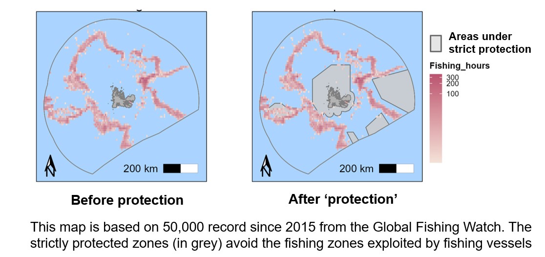
Fishing around the Kerguelen Island before and after the MPA was declared. Image by BLOOM.
“The French government is running a numbers policy, not a protection policy. It is official. This allows it to reach its ‘quantitative objectives’ without ever having to confront the real issues of destruction raised by intensive industrial fishing in metropolitan France,” BLOOM said in a media statement, referring to President Emmanuel Macron’s target of protecting 30 per cent of French waters by 2030, which has been surpassed by 3 per cent with the enlargement of the TAAF. “The President has decided to reach his target figure of ‘strong protection’ (4 per cent of the French EEZ) on the other side of the world, in the southern waters, which are barely frequented or exploited.”
These results, thus, support the case of classifying the French Southern and Antarctic Lands as a ‘misleading MPA’ or ‘paper park,’ meaning an area where conservation targets are reached on paper in terms of square kilometers protected, but where the implementation of conservation goals is questionable.