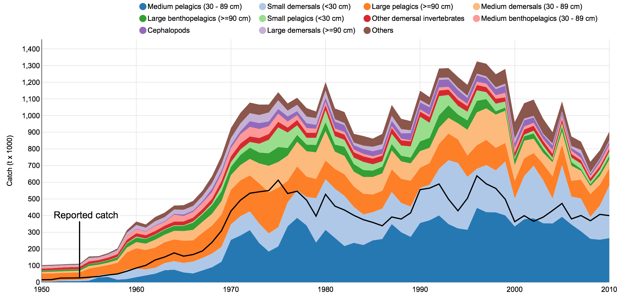
New Mapping Tool video tutorial

The Sea Around Us Catch Allocation Map is an interactive tool that allows users to view global catch using different parameters, like country, year, functional or commercial group, and taxa, from 1950 until 2010. Two or more countries can also be viewed at the same time.

The embedded video is a short and concise guide on how to use the tool.

Click here to try the tool out yourself.

And if you have further questions as to how it works, click here for more information. You will find diagrams like the one below that are complimentary to the video.

Follow us on Facebook and Twitter for more updates!

Screen Shot 2015-11-17 at 10.05.39 AM


Users weigh in on Sea Around Us website

New Homepage Map


The Sea Around Us is gaining feedback from its scientific and research users to create more robust tools and stronger web content.

On Tuesday October 26, several researchers met in Seattle, Washington to discuss improved methods for disseminating and displaying data on the Sea Around Us website.

Scientists from the Ocean Health Index, the University of Washington, and the National Oceanic and Atmospheric Administration (NOAA), among several other organizations, provided practical feedback about improvements that could enhance the utility of the web services provided by the Sea Around Us.

“Everyone was interested in the process by which the Sea Around Us reconstructs catch data, and how they can optimize the extraction of data for their research needs from the website,” said Dr. Deng Palomares, senior scientist with the Sea Around Us.

The researchers provided feedback for potential additions to the tools and data – like a user’s guide for maps; an easier system for providing feedback on data or potential corrections; and even an area for policy suggestions for non-scientific users.

Many of the researchers were impressed with the mapping tool. The tool creates visual impressions of where fish are caught and what countries are catching them – throughout time from 1950 to 2010.

“They were very impressed by the mapping tool and its potentials and said it was the most powerful tool we have ,” said Palomares.

“It was important to receive feedback today from user groups, and how they appreciate and utilize the Sea Around Us website,” she added.


Only four per cent of the ocean is protected: Sea Around Us research

Small Island

Photo by: Azrul Aziz

Despite global efforts to increase the area of the ocean that is protected, only four per cent of it lies within marine protected areas (MPAs), according to new research.

Sea Around Us scientists Lisa Boonzaier and Daniel Pauly found that major swaths of the ocean must still be protected to reach even the most basic global targets.

In 2010, representatives from nearly 200 countries met in Nagoya, Japan, and adopted the United Nations’ Aichi Targets, in a bid to stem the rapid loss of biodiversity. The countries committed to protecting at least 10 per cent of the ocean by 2020.

“The targets call for much more than just 10 per cent protection,” said lead author Ms. Boonzaier. “They require that protected areas be effectively and equitably managed, ecologically representative and well-connected, all of which will help to ensure that MPAs contribute to more than percentage targets and meet the goal of conserving biodiversity.”

In the past decade, however, some improvement has been made. In 2006, only an estimated 0.65 percent of the ocean was protected.

“Given the creation of very large marine protected areas in recent years, notably though the Global Ocean Legacy Project of the Pew Charitable Trusts, there is a chance that the Aichi Targets can be reached, which would be a major achievement,” said  Daniel Pauly, co-author of the paper and director of the Sea Around Us.

The research is published in the journal Oryx.

For more information, see http://www.pewtrusts.org/en/projects/global-ocean-legacy

Dr. Daniel Pauly participates in White House science forum

Dr. Daniel Pauly at a White House event on citizen science.

Dr. Daniel Pauly at a White House event on citizen science.

Last week Dr. Daniel Pauly was invited to the White House to participate in a forum on citizen science and crowdsourcing.

The event, held on September 30, 2015, and hosted by the White House Office of Science and Technology Policy (OSTP), and the Domestic Policy Council, aimed to “celebrate the successes of citizen science and crowdsourcing,” and “raise awareness of the benefits these innovative approaches can deliver,” according to the White House website.

Dr. Pauly was there to discuss FishBase, the global database of fish he co-founded in the 1990s that is now the largest and most accessed online database for fish in the world. Each month it receives 50 million “hits” from over half a million unique viewers.

While experts initiated the database, it functions, in large part, from the input of thousands of citizen users.

“Much of the data sets in FishBase were initiated by communities from the bottom up, and then later, were picked up by academics,” said Dr. Pauly in an interview.

FishBase includes descriptions of over 33,000 species, and over 300,000 common names in almost 300 languages, 55,300 pictures, and references to 51,600 works in the scientific literature.

“FishBase has gathered a lot of data from its users—from photos, common names, forums and blogs. There is a huge openness of the database, and it is going to increase” said Dr. Pauly.

The forum, which was titled “Open Science and Innovation: Of the people, by the people, for the people,” highlighted the work of several other innovative citizen science endeavours.

For instance, 28,000 astronomy enthusiasts have made 1.4 million classifications of potential interstellar debris using NASA’s Wide-field Infrared Survey Explorer; and 5,500 active participants have helped record over 1.5 million observations related to plants and animals for the USA National Phenology Network, leading to contributions in 17 peer-reviewed publications.

“Citizen science and crowdsourcing projects can enhance scientific research and address societal needs, while drawing on previously underutilized resources,” said the Assistant to the President for Science and Technology, John P. Holdren, in a memorandum.

Drawing on his experience with FishBase, Dr. Pauly agrees. “Governments are realizing they cannot progress in many areas without citizen participation. The idea of citizen science is not only compatible with democracy and the environmental sciences; it is essential for them,” he said.

A complete video of the event can be found here.

Links to Facebook pages for FishBase, and its partner organization SeaLifeBase.

New app to simplify fisheries data collection

Dr. Box presents the Fish Landing app to a workshop at the FishBase symposium in the Philippines. The workshop was co-sponsored by Oceana Philippines, the Philippine (), and Sea Around Us.

Dr. Box from the Smithsonian Institution presents the Fish Landing app during a workshop at the FishBase symposium in the Philippines associated with the 25th and 10th year anniversaries of FishBase and SeaLifeBase (Sea Around Us partners). The workshop was co-sponsored by the FishBase Information and Research Group (FIN), Oceana-Philippines, the Bureau of Fisheries and Aquatic Resources (BFAR) of the Philippine Department of Agriculture, and the Sea Around Us.

On the northern coast of Honduras local fishers noticed the amount of fish they caught was decreasing year after year. What’s more, it was becoming increasingly difficult to catch the amount of fish they needed to make a living.

Compounding their plight was the fact that because their catch went to local buyers and then on to domestic markets—no real catch data were available. Without these data, it is incredibly difficult to manage a sustainable fishery.

A new app could help change this. The Fish Landing app helps local buyers track the species and size of fish caught, fishing spots frequently used, and the profiles of local fishers.

The app was developed by a team of researchers from the Center of Marine Studies (CEM), and the Smithsonian Institution, led by Dr. Stephen Box from the Smithsonian.

“The wealth of data which will be collected using these tools will greatly contribute to data analysis, and can be a primary basis for any plans related to fisheries management and sustainability,” said Dr. Box at the workshop, which was organized and moderated by Dr. Deng Palomares.

The researchers initially used a paper-based system to try and track catch data, where fishers, upon returning from the ocean, would fill out forms detailing the number and species of fish they caught. At the end of each month these papers were given to researches who then laboriously digitized and analyzed the data. While relatively effective for some small communities, on a larger scale it was highly inefficient.

The Fish Landing app helps to streamline this process. Local buyers—who receive the majority of fish from the fishers—use an Android phone or iPad to keep track of the data. Through its picture-based operation system the app is easy to use.

But why would buyers want to participate? The app is a one-stop shop for business purposes, where buyers can track fish caught, money earned and paid, and who their clients are. Fishers also get more precise information about what and how much they catch and earn, and governments are given data that can be used for fisheries statistics. Data packages to be shared with governments or management agencies can be customized and adjusted to local needs and sensitivities.

Furthermore, governments will finally be able to understand the large role that small-scale fishers play in contributing to the economy and food security.

At the workshop where Dr. Box presented the Fish Landing app, two other closely-associated tools were also presented. These included a decentralized registration system that easily and rapidly creates “fisher identity cards.” Often, these are the only pieces of ID that the fishers possess.

The other tool is an onboard, cheap, self-contained, and solar powered GPS system that will help in understanding the amount of time fishers spend in certain waters, the competition for fishing grounds among fishers, and the seasonal patterns in seascape use, among a suite of other factors.

Daniel Pauly, Principal Investigator of the Sea Around Us, believes these tools together could transform the accumulation of fisheries data.

“These three items could revolutionize data acquisition for and by artisanal fishers in developing countries, including the Philippines where the presentation by Dr. Stephen Box generated considerable interest,” he said.

Dirk Zeller, Senior Scientist of the Sea Around Us, thinks these tools are a state of the art approach that not only improve data collection but also the management of small-scale fisheries, which recently received clear recognition through an endorsement by the Committee on Fisheries and Aquaculture (COFI), of the FAO’s Voluntary Guidelines for Securing Sustainable Small-Scale Fisheries in the Context of Food Security and Poverty Eradication.

“These tools and their associated direct and easy access to the data generated, will also empower local communities in their engagement in small-scale fisheries management,” he said.

The app and related tools are also being tested in Myanmar. Interest from the Philippine government and some NGOs expressed at the workshop may lead to the use of the fisheries app package, at least in some pilot areas. Dr. Mary Ann Bimbao (Executive Director of FIN) and Dr. Deng Palomares (Senior Scientist of the Sea Around Us) are in follow-up discussions with some members of the BFAR and Oceana-Philippines for future work.