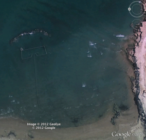
 In the Persian Gulf, large, semi-permanent fish traps take advantage of tidal differences to catch a wide variety of marine species. These traps, called fish weirs, have been used around the world for thousands of years, but only recently have researchers quantified what they catch using imagery captured from space.
In a new study published today in the ICES Journal of Marine Science, Sea Around Us Project researchers used satellite imagery from Google Earth to estimate that there were 1,900 fishing weirs along the coast of the Persian Gulf during 2005 and that they caught approximately 31,000 tonnes of fish that year. This catch is almost six times larger than the official amount (5,260 tonnes) reported by the seven countries in the region to the United Nation’s Food and Agriculture Organization.
This study highlights the utility of Google Earth and other remote sensing tools for validating catch statistics and fisheries operations in general.
You can find out more about the study here:
Press release from the University of British Columbia,
Web feature summarizing the study from The Pew Charitable Trusts,
Journal article published in ICES Journal of Marine Science.
Al-Abdulrazzak D and Pauly D (2013) Managing fisheries from space: Google Earth improves estimates of distant fish catches. ICES Journal of Marine Science. doi:10.1093/icesjms/fst178

